
How to Find Ancient Assyrian Cities Using Economics
The coolest trade econ paper I know

Trade, Merchants, and the Lost Cities of the Bronze Age is an economics paper published in the QJE in 2019 and written as a collaboration between three economists (Thomas Chaney, Kerem Coşar, Ali Hortaçsu) and a historian of ancient Assyria, Gojko Barjamovic.
The idea of this paper is to use mentions of trade on Assyrian clay tablets from nearly four thousand years ago to estimate the size and location of ancient Assyrian cities, even those whose true location is unknown. They build a model that accurately recreates the location of known cities and makes predictions for the locations of lost cities that often line up with active archaeological sites, the best-guesses of historians, and sometimes favor the guesses of some historians over others.
The authors also find evidence for extremely long-term persistence of the distance elasticity of trade as well as city size and location. The predicted size of ancient Assyrian cities in their model correlates strongly with the size of their closest modern counterparts and the costs of distance to trade seem to be the same on bronze age wagon-roads as they are on modern Turkish highways.
Data
The data for this paper comes from the ancient Hittite city of Kaneš, now known as the archaeological site of Kültepe, nestled in the hills of eastern-central Turkey.

Around 1900 BCE, this city was a flourishing entrepot. Despite being deep within Hittite territory, the economic activity of the city was dominated by a community of Assyrian expatriate traders with connections to the powerful city state of Assur, near modern day Mosul in Iraq. So important was this city to Assyrian trade that it hosted an Assyrian court that adjudicated disputes between merchants.
In ancient Kaneš, court transcripts, trading contracts, and merchant accounting were all recorded on clay tablets. Clay tablets preserve well, so this period is in some ways better known then the next several thousand years of history. The authors claim that “the closest comparable corpora of ancient trade data are almost 3,000 years later, coming, for example, from the medieval Italian merchant archives and the Cairo Genizah”
This confluence of durable medium and economic material makes Kaneš the perfect archaeological site for this project. Tens of thousands of clay tablet records were produced or stored here, all concentrated to within a few decades. The economic and political pull of Kaneš’ trading hub and outpost of the Assyrian court pulled all the major traders in the area to establish a presence here. This means there are lots of records of trade between cities that don’t even include Kaneš as archival records for agents of larger companies based in Assur or as evidence in trials. The cherry on top: the entire city burned in a fire, preserving the clay records to be recovered forty centuries later.
The authors use some natural language processing and manual inspection to narrow down from tens of thousands of tablets to several hundred unambiguous mentions of trade between two of 25 Anatolian cities that have enough trade connections with each other to be identified in a gravity model. They are using the number of mentions of trade, rather than a more continuous measure of the value or volume of trade goods flow due to data constraints. 15 of the cities in their sample have known locations, but 10 are lost and have disputed locations among historians.

Model
The central model here is the gravity model of trade which in simplest terms predicts the amount of trade between two places as proportional to the economic “mass” of the two places (e.g their population or GDP) and inversely proportional to the distance between them, echoing Newtonian gravity.
Usually, the gravity equation takes the distances and masses of countries or cities as an input and outputs a prediction of trade between them. The authors of this paper flip this around. They have some data on the amount of trade between cities, as well as the location of some known cities, and they use this to back out what the size and location of all the other cities is likely to be.
They take two steps to estimate the locations of lost cities using their model. First, they use the trade between cities with known locations to estimate the distance elasticity of trade, i.e how much does trade decrease as the distance between two cities increases. Then, they try to fit the model’s predictions over the shares of trades between each city pair in the network to the observed data by choosing different latitudes, longitudes, and productivities for each city.
Results
Barjamovic et al. aren’t working with a ton of data here, only a couple hundred trade mentions. Nonetheless, their estimates seem good.
One can measure the performance of their model by testing its internal validity: how well can the model predict the location of a known city if we act like its location was lost?
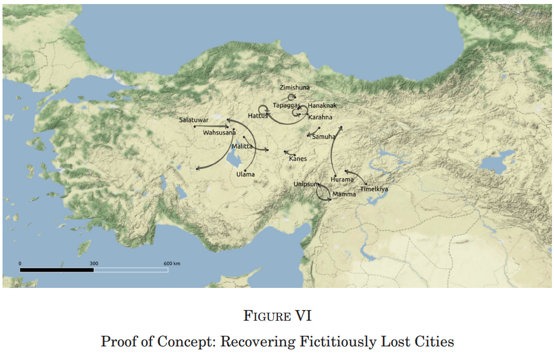
Among the nine centrally located cities, the average distance between the true and estimated locations is 40 km (median 33 km), and often substantially lower (Zimishuna ˇ = 1 km, Hattusˇ = 3 km, Tapaggasˇ = 17 km, Hanaknak = 19 km, Kanesˇ = 33 km). We conclude that our proposed inverse-gravity estimation of the location of lost cities is reliable for central cities but less precise for peripheral cities.
Below is a map showing the labeled, true locations of each city connected to the predicted location with an arrow. There are a couple of big misses, but this is still impressive accuracy given the paucity of data they are working with.
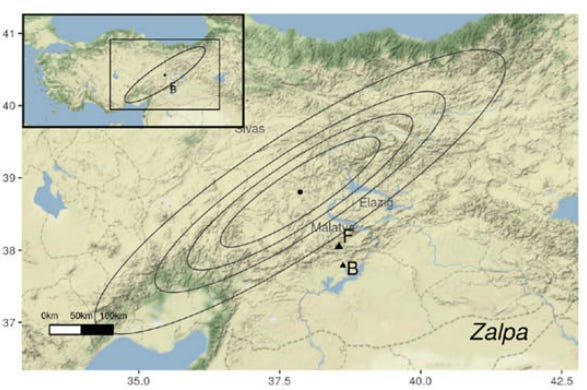
Next, the authors compare their model’s predictions of the locations of the lost Assyrian trading outposts with the best guesses of historians. Sometimes, their prediction is close to the best guess of both historians, marked with F or B, as in the case of the lost city of Kuburnat.

Other times, their prediction favors the guess of one historian over the other, as in the case of Washaniya.

Still other times, the confidence intervals on their guess are wide and not particularly close to the external validity of historian’s guesses.
The results here aren’t perfect, but this is still pretty incredible stuff. A bunch of economists are able to accurately predict the locations of 4,000 year old cities using nothing except a few hundred sentences like this:
(I paid) 6.5 shekels (of tin) from the Town of the Kanishites to Timelkiya. I paid 2 shekels of silver and 2 shekels of tin for the hire of a donkey from Timelkiya to Hurama. From Hurama to Kanesˇ I paid 4.5 shekels of silver and 4.5 shekels of tin for the hire of a donkey and a packer. (Tablet AKT 8/151, lines 5–17)
Long-term Persistence
The findings above would be enough to make a great econ paper, but the authors also use their data to find supporting evidence for a remarkable persistence of city location, size, and the distance elasticity of trade.
The authors use their gravity model of trade as well as data on the local topography to predict the population sizes of the ancient cities in their sample. They find that higher city population in ancient Anatolia is a good predictor of modern city size 4,000 years later, even after controlling for other geographic amenities like crop yield.
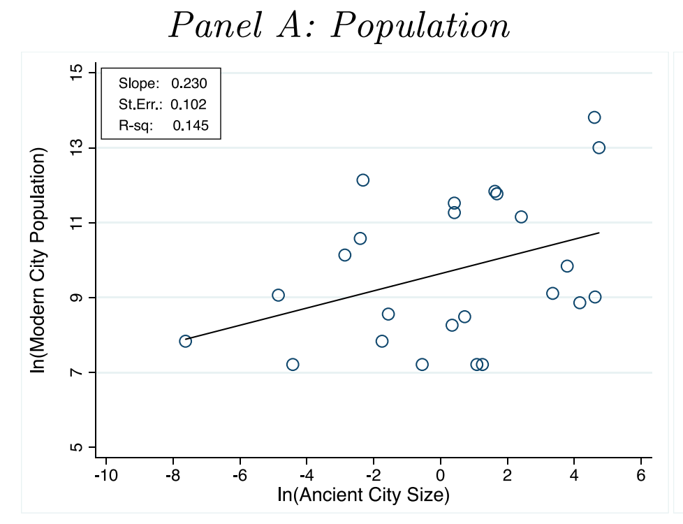
There are two non-exclusive possible reasons for this. First is time-invariant advantages to certain locations: One way they predict the size of ancient cities is by looking for the confluence of natural topographic roadways through the Anatolian mountains. Cities with locations near more confluences are predicted to be larger than others and these natural advantages don’t change much over time, so city population size rankings won’t change much either.
Second is path dependence. There may be many suitable locations for a city given geographic advantages, but once one is chosen, that location gains the inimitable advantage of already having people, history, and infrastructure, thus preserving that spot as the ideal.
There is another great paper, Resetting the Urban Network: 117–2012, that measures the effect of geographic characteristics versus path dependence by using the complete collapse of the Roman Empire in England vs it’s greater persistence in France as an experiment. The most naturally advantageous spots for cities changed both in England and in France over the centuries between Roman rule and medieval times, especially as a result of advances in sea trade making coastal access more important.
But in France, the Roman urban fabric was more maintained through the catholic church and other institutional carry-overs while in England urban life collapsed much more completely. Thus, previously Roman sites in England had less path dependent advantage when cities reformed and indeed we see that city sites moved more in England than they did in France.

The distance elasticity being constant over time is also a bit of a puzzle. This parameter measures the rate at which trade volume falls off with distance. The authors find that this rate is the same today as it was 4,000 years ago. Ancient Assyrian traders were moving camels and wagons across dirt roads and through completely different political institutions, while modern Turkish truckers are driving 18-wheelers on highways but they both trade about 4x less between cities that are twice as far away. This finding of a persistent distance elasticity of trade through massive technological change is replicated in lots of other economic research.
The best way I’ve found to think about this puzzle is to imagine the distance elasticity of trade like the half-life of Uranium. If you start with a pile of Uranium and wait around for 700 million years, you’ll have half as much left. If you double the amount of Uranium you start with, it will last much longer and you’ll have more after 700 million years, but the half-life hasn’t changed.
Similarly, we have much larger volumes of long-distance trade than we did in the past, transported by new technologies like cars and ships. But this is because we start with a much larger volume of production so that after it decays across long distances, we’re still left with large volumes, not because the decay rate has changed. So technology acts like an upwards shift on the curve of distance vs trade that increases the amount of goods sent to all locations proportionally, rather than increasing long distance trade more than short distance trade. This still leaves open why the distance elasticity is what it is (between -1.2 and -1.9), but at least explains why advanced technology might not change it over time.
This paper shows, perhaps better than any other, the power and versatility of economics. I don’t think any other field of researchers could have struck up a collaboration with an Assyriologist and identified 4,000 year old invariant characteristics of cities and trade and make inferences on the locations of lost trading posts from a few hundred points of data. An inspiring piece of work!
This is an incredible paper, thanks for writing it up Max!
> This still leaves open why the distance elasticity is what it is (between -1.2 and -1.9)
If we take -1.55 as the point estimate, is the following interpretation correct?
"Increasing the distance between a city by 1% leads to a -1.55% reduction in trade"
> So technology acts like an upwards shift on the curve of distance vs trade that increases the amount of goods sent to all locations proportionally, rather than increasing long distance trade more than short distance trade.
It's still surprising that this increase would apply proportionally to *all* locations. Selling girl scout cookies door to door or setting up a lemonade stand isn't much different from local trade in the ancient world, but the development of ocean-spanning freighters, dismantling of trade barriers, and spread of theories of trade and capitalism should have all disproportionately boosted long-distance trade over short-distance.
> Then, they try to fit the model’s predictions over the shares of trades between each city pair in the network to the observed data by choosing different latitudes, longitudes, and productivities for each city.
What does this mean? Does it mean using multiple distance readings from city X (e.g. A is 500km away, B is 600km away, C is 400km) to trilaterate the position of X, like a GPS positional fix?